Just when many people had dismissed the Cold War as a relic of the past, it resurfaced with a vengeance last week as authorities arrested eleven alleged Russian spies in the United States and Cyprus. But what a difference a decade or two makes, I thought. No more weather-beaten Burberries or dead letter drops in grungy East Berlin cafes for Anna Chapman and company. Instead Chapman was observed transmitting information to a Russian intelligence officer over a wireless network at Starbucks. How wonderfully 2010.
The Cold War never really left us, however: intelligence agencies on both sides of the former Iron Curtain continued snooping long after the fall of the former Soviet Union. And all this determined espionage has generated some unexpected spinoffs for science–archaeology included. As Spying on the Past: Declassified Satellite Images and Archaeology, a new exhibition at the Peabody Museum of Archaeology and Ethnology at Harvard University, reveals, spy photos from the 60s and 70s are showing archaeologists many things they have never seen before.
The spy photos in question come largely from the American government’s Corona program, a reconnaissance satellite system that surveyed vast regions of the globe from 1959 to 1972 for Soviet missiles, and the KH-7 program, a spotter satellite that took high-resolution images from 1963 to 1967 of suspected military sites.

Harvard University archaeologist Jason Ur has cleverly employed these photos, for example, to solve a stubborn archaeological conundrum: why did the Assyrian king Sennacherib embark on a massive canal-building program in northern Iraq in the early 8th century B.C.? Sennacherib is best known today for his rather checkered military record. According to Old Testament accounts, he destroyed the northern kingdom of Israel and carried off its tribes before embarking on a disasterous seige of Jerusalem.
Earlier archaeologists hypothesized that Sennacherib built the extensive canal system to water verdant parks and gardens in his capital, Nineveh. They based this idea on two sources of fragmentary evidence–the inscriptions they found on irrigation structures and the historic maps drawn by early archaeologists and travelers who visited parts of the region on foot.
Ur was able to look at a much bigger picture. By studying the old spy photos, he detected a complex network of earthworks, aqueducts, and more than 71 miles (114.8 kilometers) of canals. This network of waterways extended far beyond Nineveh, to a series of small, evenly spaced agricultural hamlets. Based on evidence from earlier fieldwork, Ur suggests that little hamlets were populated by Sennacherib’s captives, quite possibly including the Israelites. “Almost a half million people are counted as deportees in Sennacherib’s inscriptions,” Ur told me in an earlier interview, “and their most common destination was Assyria and its capital cities.”
In other words, the canals had nothing to do with pleasure gardens. They irrigated far-flung fields and were tended by an army of agricultural slave-laborers. If that isn’t a chilling, Stalinist, Cold War image, I don’t know what is.
Upper Photo: Anna Chapman courtesy of Wikipedia.
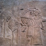
Lower Photo: Relief depicting Assyrian archers attacking a besieged city, most likely in Mesopotamia. From the Central Palace in Nimrud and now in the British Museum, London. Circa 728 BC.
That is interesting about Nineveh. The book Jonah describes the city as being a 3 day walk. If one was walking fast it would take about 3 days to traverse 70 odd miles.
Also, an archeologist with a name of Ur was born to study Meopotamia.
Cool point about Nineveh. Now I will have to read Jonah!
I also believe that the Cold War never really left us. At some point in time, it will return. Jason Ur did a great job in studying Mesopotamia, especially the 71 miles of canals.