This post originally published in May of 2015, which, considering the age of the Bering Land Bridge, wasn’t that long ago.
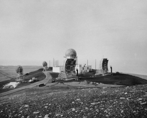
During the Cold War, a U.S. Air Force telecommunications network was erected in Western Alaska, a series of gray metal radio-towers like obelisks on a hilltop over the town of Nome. Each points a different direction, meant to bounce tropospheric messages from the Russian border to the US. Last used in 1985, the network has been abandoned.
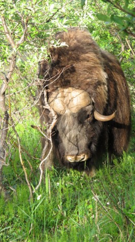
I visited the White Alice site one summer, gathering qivuit, the soft winter fur of muskox, which hangs in branches of overgrown shrub-willow around the radio towers. In low summer light and a stiff mountain breeze from the west, I rubbed qivuit between my fingers. It smelled of earth and musk. I’d run into muskox as I walked up here. They were grazing in the willows, and I startled one as I climbed through the vegetation. Rather, it startled me. I parted branches and found myself about 8 feet from the thick-horned head and a drape of winter fur molting in the willows. The animal looked up, flared two dark, wet nostrils, and went back to grazing. It seemed so unfazed, I snapped off the picture below and backtracked around it.

The towers looked like drive-in movie screens made of corrugated-metal, a visual oddity among the muskox. In the old pictures, the area around the White Alice site look like an Arctic moonscape. Now, it is overgrown in shrub-willow tagged with muskox fur. From the towers, I looked across the blue half-circle of Norton Sound and the Bering Sea beyond. Out of view is Russia, and the other side of the world.
This was a perfect view for what was once the Bering land bridge. The former landmass ramped up onto North America during the Ice Age. Sea levels were 400 feet lower at the time, and this place where the land bridge touches Alaska was not an assortment of towers, but mammoths, mastodons and American lions. Muskox were present in Western Alaska in the late Pleistocene, but then they were the smaller of beasts.
Picturing the Bering land bridge, you might think of an actual bridge, a teetering walkway between two continents. Instead, it was an entire landmass fusing Asia to North America, a subcontinent known as Beringia. Twice the size of Texas, the land bridge itself was monotonously flat geography near sea level. Standing here, you would have been looking not across water, but a dry puzzle of larch, scrawny spruce, and open steppe on which the megafauna like wooly mammoths grazed.
Recent finds have strengthened the theory that waves of the first peoples came through this part of Alaska. No local artifacts have been found to suggest dates earlier than 13,000 years ago, but genetic evidence has been moving out front. A paper in Scienc announced that a 12,000-year-old human skeleton found in the Yucatan shows “Paleoamerican craniofacial characteristics and a Beringian-derived mitochondrial DNA.” This means the girl, who fell to the watery bottom of a cenote, had an ancestry that came from from Asia across the Bering Strait. Maternal lineage taken from the girl’s molar is one of many missing links tying native populations of the Americas back to Asia through here. Earlier this year, the remains of a Clovis-age boy from 13,000 years ago in eastern Montana, showed the same genetic drift, Siberia to the Americas.The crossing of the Bering Strait from west to east on or around the ancient subcontinent of Beringia is becoming less a theory and more of a given.

Other stories of how people first arrived in the Americas will no doubt arise as genomic research builds. For now, the story has strengthened around the Bering land bridge.
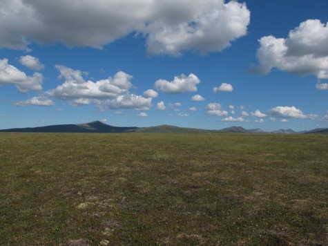
Days later, I walked along the shore of Norton Sound in clear, subarctic sunlight. After a few miles following the gravel beach and its occasional encampment of gold dredgers, I walked into tundra and sat on dry, lichen-crunchy ground among blowing cotton grass. To one side was wide blue water. To the other was one of the first mountain ranges people may have seen on the American side of the land bridge. I thought this was the country they’d walked upon, this the first place where human footprints may have landed.
I so enjoyed being in Nome – and near that site – with the muskox. Love Craig’s perspective of the ancient’s.
Atlas of a Lost World fascinated me, especially your stories about St. Lawrence Island and the people “mining” artifacts to sell from submerged village dwellings. Not only did it take away any shred of panic I had about climate change seas rising, it also reminded me of a beautiful book I owned long ago of folk tales of the people of the Amur River regions. Illustrations in the book showed people and modes of dress that looked very much like Inuit and Aleut people of western Canada and Alaska. A dear Dine friend of mine told me how Athapascan had a lot of words that were similar to those spoken by the Mongolians. Fascinating stuff
Whenever I read your posts, Craig, I’m always reminded of how little of the world I’ve actually seen. How much wild you’ve seen near abandoned radio towers and working meteorological base stations, the kind of places that scientists and technicians only seem to dare to trespass. And how much history, you see too in upturned rocks & in qivuit snagged on a willow branch.
Wonderful account, as always, Craig. The qivuat details makes us actually feel the story.
But I’m curious about your thoughts regarding two recent stories about the first humans in North America, both from reputable sources:
https://www.cnn.com/2021/09/23/americas/footprints-humans-arrive-in-north-america-scn/index.html
https://www.stuff.co.nz/science/300064029/stone-tools-suggest-humans-in-north-america-26000-years-ago
The former suggests a 23,000 years ago evidence from the New Mexico footprints, and the latter a 26,000 worked object from a Mexican cave.
Thoughts
So lovely to read your description of the natural history of the area. I haven’t been, but my grandparents met and married in Nome in the 30s, and my parents met when my grandfather and dad were working on the construction of the Dew Line (not sure I have the name correct), of which this radar site is a part. I have faded black and white family photos of the Nome surroundings, but the color in your pictures and and the color in your language really bring the landscape to life. Thank you.
Any hand spinners out there looking for qiviut? I have a small pouch full that I gathered near the villages of Buckland, Ambler and Kobuk almost 40 years ago. It’s still beautiful but un-spun….