 For me, geography is a time machine. The shape of the land sets the dials. Artifacts are keys.
A few days ago I was watching for mammoth hunters out a train window. Climbing through the Rocky Mountains on the California Zephyr, I looked for spear bearers in the bony canyons and pine woods along the eastbound line. I thought I might catch a glimpse of them as they found gaps between glaciers, a way across the mountains where glaciers are now all but gone. They were on their way to Boulder, CO, or at least the Ice Age location of the city when it was a slope of retreating permafrost in a country of mammoths, camels, and giant bears.
In 2009 a landscaping job at a private residence in Boulder turned up a cache of Clovis stone tools dating to around 13,000 years ago. The types of rock found in the cache reveal a route followed in part by the Zephyr up and over the Rockies. Traced back to quarry regions where they were first picked up, the farthest rocks in the cache come from western Wyoming and northeast Utah, 300 miles and many mountains from where they were ultimately dropped.
These tools have produced residue of proteins from Pleistocene horses, camels and bears. At the time, glaciers were stepping back and new west-east routes were forming across the Rockies. Clovis people appear to have been blazing a path.
The cache was found while digging what was to become a koi pond. The tools had been hidden under a boulder on a hill slope near a creek in what is now a prosperous Boulder neighborhood. Known as the Mahaffy cache, named after the owner of the house, it consists of Paleolithic flakes, cores, and blanks, including a smooth leaf of pink-orange stone the size of a salad plate. The pieces all exhibit what is known as “bag wear” where they rubbed against each other in transit. The farther away the rock source, the more the bag wear.
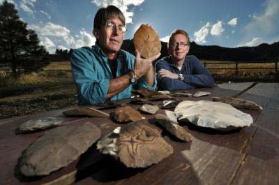 In his findings on the discovery, University of Colorado archaeologist Douglas Bamforth, wrote, “I have noted that the artifacts in the Mahaffy cache may have changed hands as they moved across the mountains. They also may have been collected by different people who subsequently traveled together into the Boulder area; we cannot be certain. However, there is at least some reason to argue that Clovis people carried the cache in a single, relatively fast trip.”
Pieces from farthest away are a quartzite probably picked up around the Uinta Mountains in the northeast corner of Utah. The cache also contains pieces of what is called Bridger Basin chert, a handsome, striated, nut-brown rock from the western Wyoming. As if leaving a trail of breadcrumbs, the next stone is Kremmling chert, a quartz-like rock from Middle Park, a region of high rolling hills and rocky scarps in north-central Colorado, just over the Continental Divide from Boulder.
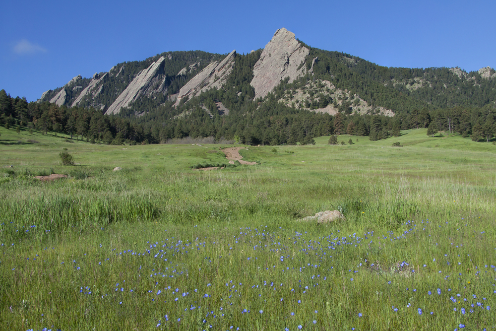
Put all together, these rocks form an obvious walking route from Utah across the Colorado-Wyoming border eastward to the source area of Kremmling, and over the mountains to the foot of the Front Range. There, the cache was dropped beneath the stunning badges of the Flatirons, an obvious landmark that can be seen from 20 miles out on the plain.
On its rise into the mountains, twisting through canyons and tunnels, the Zephyr rattled and I stayed at the window imagining Ice Age people out there. The surface of the land has not changed substantially over 13,000 years. Mountains are still in the same places, rivers flowing where there used to be rivers. I saw them climbing over rock outcrops, skirting ledges to get over creeks that would have been swollen from melting icefields.
The reason for the train being here is probably much the same for people being here in the Ice Age. It is a way across a significant mountain range. The Zephyr follows a freight line on the Union Pacific Railroad, a primary supply route from Nevada to Denver. Where it crosses the continental divide (now through a six-mile tunnel 3,000 feet underneath a mountain summit), nearly a hundred native game drives have been archaeologically identified. Before the tunnel, which was built in the 1920s, the route served as a wagon train road and a passage for livestock getting to Denver. It has long been a thoroughfare.
Traveling east through the six-mile-long Moffat Tunnel, the Zephyr emerged on the other side of the Continental Divide and began its descent along the Front Range through chains of dynamited tunnels. The sky began to open as the Rockies plunged toward the plains. Coming through the soaring, shark-finned Flatirons over Boulder, I could see the neighborhood miles away where the Mahaffy Cache was found.
These were the same foothills and plains they would have seen. Finding themselves at the edge of one of the continent’s largest and most well defined provinces, the Great Plains rising to the towering fence row of the Rockies, this would have been a likely place to leave a cache. A likely place to put a railroad over the mountains. A likely place for a person to end up today.
Perhaps Clovis people found the remains of older stone tools on the ground, telling them they were on a reliable route .Thirteen thousand years ago, a person could have done the same as me, scanning the edge of the mountains looking for where people came before, tuning their own time machine until they could see what happened here long ago.
Photos: Shutterstock and image by Glenn Asakawa, University of Colorado, of Douglas Bamforth and Boulder resident Patrick Mahaffy, who owns the property where the cache was found.