 Remember that billowing cloud of ash from Iceland that floated over Britain and other parts of northern Europe this past spring, shutting down airspace from London to Hamburg and filling airports with fuming travellers? It wasn’t all bad, I discovered yesterday. In fact if you were an archaeologist, particularly a British archaeologist, that plume of frozen magma had a real silver lining. It created, in concert with one of the driest springs in recent memory in England, almost perfect conditions for the discovery of cropmarks.
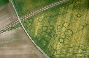
Until yesterday morning, I had never heard of cropmarks. But it turns out that I’ve been missing a lot. Cropmarks are very cool phenomena–a vast green geometry that signals the presence of buried archaeological sites. Think circles, rectangles, squares, and other patterns created by vegetation lying atop buried ruins, from Bronze-Age causeways to Iron-Age tombs.
There is no such thing, it seems, as vanishing without a trace. An old ditch, for example, eventually fills with leaves and other organic material and collects water: strong green vigorous plants take root above it. The opposite is true, however, of a stone foundation wall. The buried rock drains water away from the surface and provides little sustenance to plants. Only scraggly growth ekes out an existence along such a wall. And these differences in vegetative growth rates create faint green footprints that can be seen from the air — cropmarks.
And here’s where the ash cloud and Britain’s arid spring come in. British archaeologists are fond of chartering small aircraft to look for cropmarks, but some years are better than others: 2010 was a humdinger. The ash plume grounded the big jets, but it posed no danger to piston-powered Cessnas, so archaeologists flew for weeks on end over the usually forbidden airspace around Gatwick and several other major British airports. Moreover, the bone-dry weather helped accentuate differences in vegetation growth, even in normally hardy grasses.
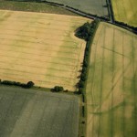
 The results were glorious. On one day alone, a team flying over the plains of Holderness in Yorkshire discovered 60 new sites, including trackways, entire settlements and field systems. In Dorset, the airborne surveyors spotted the corner of a vast rectangle in a Dorset field. It proved to be a buried defensive wall surrounding a previously unknown 1st century Roman camp, a very rare discovery in southwestern England.
The rains of July restored lush green to most fields and brought the aerial season to a close. But even now, the folks at English Heritage are marveling at their luck. A natural disaster that caused so much angst and frustration to travelers has proven a true archaeological windfall. “It will take some time to take stock of all the sites we have photographed,” noted Damian Grady, an aerial specialist at the organization, in an official announcement, “but we expect to discover several hundred new sites across England.”
Upper Photo: Cropmarks of ancient burial chambers at Grezac in France. Photo courtesy of Cliché J. Dassié
Lower Photo: Cropmark of Roman Camp in Dorset. (Look in the upper left hand corner.) Photo courtesy of English Heritage